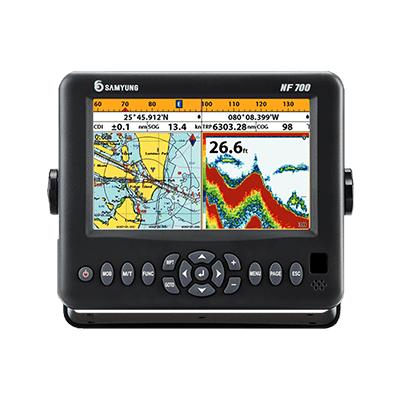
Samyung NF 700
Color GPS Chart Plotter Fishfinder
Built-in Standard Chart
Samyung NF 700 Color GPS Chart Plotter Fishfinder is a precision-crafted GPS chart Plotter with high-performance receiver for the Global Positioning System constellation of satellites, providing precise location data with a host of navigation features.
- Wide 7″ High resolution TFT LCD
- 10 Steps Adjustable LED Back Light
- NAVIONICS® Gold SD Card
- 128 MB Internal Memory
- Built-in Standard Samyung Chart
- Dual Frequency (50/200 KHz) Transducer for Detection of Small Fish
- Output: 600W, Max. depth: 600M
Key Features
- Wide 7″ High resolution TFT LCD
- 10 Steps Adjustable LED back light
- NAVIONICS® Gold SD Card
- 128 MB internal memory and built-in Standard Samyung Chart
- Individual button for navigation GOTO and MOB
- NMEA(0183) interface (AIS, NAVTEX, DSC etc.)
- Multiple languages available including English, Chinese,Russian, Thai, Malay etc.
- DGPS (WAAS, MSAS, EGNOS)
- Save a chart image on internal memory (128 MB)
- Save internal data on SD card
- View and print saved data on SD card
- User-friendly operation type by using icon for each menu
- NMEA 0183 interface (AIS, NAVTEX, DSC etc.)
- 4 split screens (Chart, Data, Highway, Fish-finder)
- Using dual frequency (50/200 Khz) for detection of small and individual fish
- Clearly shows fish targets close to the seabed by Split zoom/Split bottom (Output: 600W, Max. depth: 600M)
Scope of Supply
- Main Unit (Display 7″ Color TFT LCD)
- GPS Antenna Unit (SAN-60)
Options
- Transducer P58 (Transom) for NF-560, NF-700
- Transducer B45 (through-hull) for NF-560, NF-700
- Navionics chart (SD card) Africa

